flyzipper
Rollerblading along the road
Celebirdy of the Month
Mayor of the Avenue
Avenue Spotlight Award
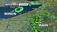
I thought this radar image was quite cool as fall bird migration starts in my area (I'm not too far southwest from London in the top left).
That body of water is Lake Erie and the northern coastal outcropping is Long Point (about 40 kilometres (25 mi) long and 1 kilometre (0.62 mi) across at its widest).
That body of water is Lake Erie and the northern coastal outcropping is Long Point (about 40 kilometres (25 mi) long and 1 kilometre (0.62 mi) across at its widest).
Long Point is an example of sand dune and sand-spit formation in the Great Lakes region. It is the largest erosion deposit formation in the Great Lakes, created by water-borne sediments swept eastward and deposited in part along an underwater glacial moraine. Habitats on and surrounding Long Point include woodlands, sand dunes and bluffs, marshes, ponds, meadows, beaches and lakeshore. The complex is the largest biophysical formation of its kind in the Laurentian Great Lakes of North America.[4] North of the peninsula lie several islands,[5] including Ryerson's, Second, and Snow.
In 1982, the Long Point National Wildlife Area was recognized as a wetland of international significance under the Ramsar Convention. In 1986, Long Point Biosphere Reserve was designated as a World Biosphere Reserve by UNESCO and as a globally significant Important Bird Area by Bird Life International.[4] The Ontario Ministry of Natural Resources classifies Long Point as a Macrosite, an area that contains numerous ecological or geological significant zones,[6] such as Areas of Natural and Scientific Interest.
The region is an important location for bird migration in spring and autumn. It is a major staging area for a variety of waterfowl. "Long Point itself is one of the most important wetland complexes for migrating waterfowl in southern Canada, and is reported to receive the highest waterfowl use (based on numbers of waterfowl days during spring and fall migration) of any area on the Great Lakes (approximately 4 million days per year). Up to 30,000 Tundra Swans pass through the area in spring, and up to 8% of the world's Canvasbacks congregate in the area on any one day during spring and fall," according to a report by the Long Point World Biosphere Reserve.[7]
In 1960, the Long Point Bird Observatory was established to monitor migrant birds on the point. It is North America's oldest bird observatory. As a result of a growing national focus towards saving the birds, the organization was renamed Bird Studies Canada in 1998. Its national headquarters overlooks Long Point Inner Bay on the western limits of Port Rowan, adjacent to base of the peninsula.
(source)
(source)


